
Ua Huka
-
The Wonders of Fatu Hiva and Ua Huka (Despite the Goats and Horses)
Sarah and I have embarked on our final tour of Marquesas before we head off over the blue yonder once again in search of unexplored lands (unexplored by us anyway). We set sail from Hiva ‘Oa having bidden farewell for a time to some new friends and pointed Bob’s bow toward Fatu Hiva, 45 miles to the SSE. It was a little tight on the breeze but we made it without having to tack and pulled into Hanavave Bay (Baie Des Vierges) for the second time with the intention of giving it a proper opportunity to impress us. I have to admit I was a unenthused by the prospect of heading 45 miles upwind in order to visit a bay that we’d been to before, but Sarah persuaded me and I’m very, very glad that she did. It really is spectacular – towering rock structures loom imposingly over the village of Hanavave, jutting from the face of a cliff that must be at least 1000 feet high. I can’t help but wonder if the tradition of ‘tikis’ (google for an explanation) may have been originally inspired in the first Polynesian settlers by these very same cliffs. They seem to be almost alive with the faces of giants seemingly carved into the rocks themselves. Very cool.
Determined to make the most of it I think we did Fatu Hiva justice in the short time we were there – we explored a cave that we learned about from a fellow cruiser, walked the remains of an ancient village that was buried by a catastrophic landslide, undertook a 17-kilometre hike over the mountains from one bay to the next, visited one of the most beautiful waterfalls I have ever had the pleasure to visit and generally enjoyed ourselves. There were, however, a couple of hiccups.
Our dinghy, Numpty, is incredibly versatile. It’s by no means the best-looking, or even the safest on account of it’s distinct lack of stability, but it’s light-weight, motors economically, rows well and, we hope, sails well. In Galapagos I measured, bought and cut some seasoned bamboo for a mast and boom. In Taravai I built a dagger board out of plywood and fibreglass, and figured out a system for a steering oar. Finally, about 6 weeks ago, a fellow cruiser gave us an old genoa that he was going to throw away and I was able to commence work on cutting it down to make a sail. I finished it in Hiva Oa and took it out for the first sea trial, but there really wasn’t much wind at all. I could tell that she’d sail well in a decent breeze but the wind was so fluky that it ended up being a frustrating experience overall. In Fatu Hiva one afternoon a land breeze sprung up so I decided to give it another go. Sarah and I both climbed in this time, but of course as soon as we got into the boat the breeze died and we were back to paddling. Never mind. Perhaps tomorrow. “Should we take the mast out overnight?”, Sarah sagely suggested. “Nah, it’ll be fine”, said silly me.
Hanavave has a strange quality. Those same spectacular cliffs of which I spoke earlier have the effect of compressing and concentrating any breeze from the East and spitting it out across Hanavave Bay with storm-force ferocity. 60-knot gusts are not unheard-of. At night, the added effect of the cooling landmass and the cold air coming down from the mountains makes these gusts even stronger than they are in the day. Unfortunately, this was our first experience of this phenomenon and we weren’t ready for it. More precisely, Numpty wasn’t ready for it thanks to my lack of foresight and planning. I got up for a pee during the night and was dismayed to find Numpty capsized astern of Bob. Goodbye two pairs of flip flops, one oar, one paddle, an anchor, a decent line and the centreboard. Two good things came out of it – we didn’t lose the mast and sail because I’d lashed them down and, more importantly, I learned a lesson in humility. It could have been much worse – we could have lost the dinghy, and that would have been a distinct inconvenience.
The second hiccup came as we were leaving. Internet access and therefore weather information are not easy to come by, but we’d managed to get a wind forecast for the local area and decided on a good day to sail the 40 miles up to Tahuata, where a pod of very playful dolphins is said to be in residence and manta rays are veritably prolific. We’d decided we had plenty of time, that we could have a coffee, some breakfast and then set sail at about 10am with plenty of time to make it to Tahuata before dark. This was, in fact, to be our most leisurely departure to date, since we usually find ourselves having to set sail either very early in the morning or late in the evening. We knew it sounded too good to be true. As we were pulling up the anchor a friendly French sailor shouted over that today there would be ‘un horreur!’, a storm.
“Today?”, I shouted back.
“Yes!”, said she.
“Here?”, I shouted again.
“Yes!”, said she.
Now, this didn’t agree at all with our weather forecast. A storm? Here? In Marquesas? Surely we would see that on our weather forecast? They must be mistaken. Besides, after our experience with the wind gusts the last place we wanted to be if it got really windy was in Hanavave Bay. We set sail towards a beautiful sky and picked up a lovely 15-knot Easterly breeze, just as forecast, as soon as we’d cleared the headland. But there was something else visible as we cleared that headland – an impending wall of nasty, dark, wet and occasionally flashy doom. Of course, they didn’t mean a storm storm. Not a tropical cyclone or even a depression. Just a very active thunderstorm. After all, the declination of the sun at the moment is right around our latitude – it makes perfect sense. How stupid of me not to realise. We’d only managed to download the wind forecast but they had the full picture.
We took some consolation from the fact that we weren’t the only idiots out here and decided to press on. A French catamaran had left the bay about half an hour before us and we could see them clearly about 4 miles ahead of us. The storm front reached them first, and the last thing we saw of them was a massive bolt of lightning striking the water right next to their boat.
There are few situations less appropriate to be in during a lightning storm than at sea in a sailing boat. You’re surrounded by a relatively flat plane with zero features, and you’re bobbing around in a silly artificial hole-in-the-water with a 50-foot metal spike sticking straight up into the air. On the very top of that spike is a collection of antennas and other stuff that make the perfect lightning-attraction apparatus. We’d shoved all of our electronics into the oven (including the radio, which I’d disconnected from it’s usual mounting) and were attempting to rationally decide what to do next about this considerably-less-than-perfect situation when a powerful bolt of lightning struck the water approximately 2/3 of a mile off our starboard bow. You could see the water erupt and vaporise where the bolt had struck. Well, that decided it! About ship! We turned straight around and raced back toward the blue skies and relative safety of mountains and land.
Now, I want to have a bit of a gripe about some of the information that is published online about these islands, and about cruising advice in general. When we headed back to Fatu Hiva that day it was going to be too hard to make it back to Hanavave, so we decided to give Omua, the other town in Fatu Hiva, a try instead. The literature is lacking for feedback on this bay as an anchorage but we’d heard from another cruiser that it was fine so long as there wasn’t a big swell running. We found that to be the case – in fact we preferred it to Baie des Vierges as there were no violet gusts from the cliff faces and the bottom where we were anchored in 10 metres was unobstructed sand and gently-sloping. By contrast, in Baie des Vierges our anchor was in 44 feet of water but Bob (with 250 feet of chain out) sat in 100 feet – a steep slope. There is a document called the ‘Marquesas Compendium’ which is available on line and which I would recommend to any future visitors to this area, but I would advise caution when using it to decide where it is and isn’t good to plan your stops. There is only one entry in it concerning Omua Bay, and the writer states categorically that ‘it is not suitable as an overnight anchorage’. Poppycock! They never stayed because they didn’t want to and weren’t comfortable with the weather at the time that they visited. It is my firm belief, however, that any anchorage with good holding and an unobstructed bottom is an excellent anchorage under certain weather conditions. To state that any such anchorage is always ‘unsuitable’ is short-sighted in my opinion. We loved it at Omua.
I have the same gripe about the information that is published about our current anchorage here in Ua Huka. We arrived here a few days ago after a beautiful, excitingly fast overnight sail from Fatu Hiva and are currently anchored by the village of Hane. Ua Huka may be my favourite island so far, and I regret that we have not visited here earlier and spent more time here. Two days ago we enjoyed a lovely day frolicking among an area of rock pools known as ‘the swimming pools’, yesterday we had the good fortune to be introduced to a wonderful lady who dropped everything to spend the day driving us all over the island and taught us more in one day about Marquesian culture than we’ve learned in our entire time here to date. Today Sarah spent the afternoon with that very same lady and her family talking and learning how to cook traditional Polynesian cuisine over an open fire. It’s been phenomenal for us. The only account of Ua Huka in the Marquisas Compendium is from a boat that turned up, found the anchorages untenable due to a large swell, left immediately having never been to shore and complained that the large numbers of goats and horses spoil the landscape, as they were sailing away! In fact, I am informed by a reliable ecologist that the goats and horses maintain a unique habitat (in the ‘early-successional stage’) which promotes diversity of certain species. The locals here have also managed, through intense hard-work and dedication, to thus far prevent invasion by the Black Rat, which is so damaging to ecosystems on other islands. The coconut trees on Ua Huka are twice as lush as on other islands, native bird populations are able to thrive and it is the last remaining refuge for the endemic Ultramarine Vini Bird. It pains me that hundreds of cruisers will have read those short-sighted and uninformed accounts in the Marquisas Compendium and pre-formed judgments about these locations based solely on those accounts. Of course it is true that one must always be alert to the weather (it’s currently calm where we are anchored but we are told that in May, June and July we might be amidst breaking waves) but if one were to anchor only in the bays and locations that are recommended by the guide books* they would miss out on a smorgasbord of experiences.
Tomorrow the swell is forecast to be from the South, so I’m going to take the dinghy and practice surf-landings under oars (well, one paddle and one oar…….) and then maybe we’ll go for a snorkel. I don’t hold out much hope for it being enjoyable though – I’m sure the view will be spoiled by all the goats and horses.
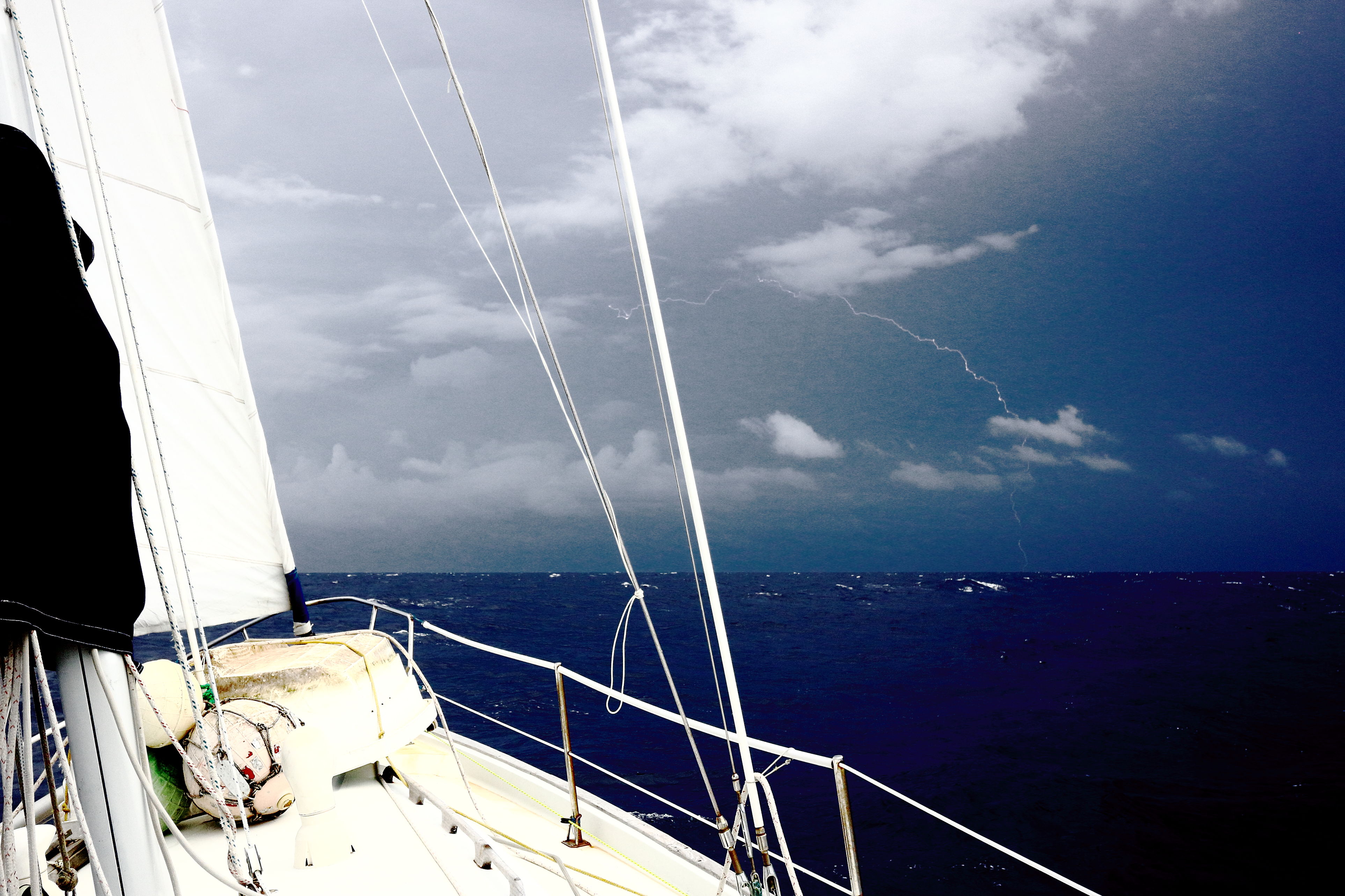
While I was running around trying to minimise our chances of fiery death, Sarah was occupied trying to get photographs of the lightning bolts that were crashing down to the sea right next to us. It was worth it, because as it turns out we didn’t die and she actually succeeded! 
The spectacular cliffs around Hanavave. Don’t they look like faces in the rocks? Or have I been at sea too long?……… 
‘The Swimming Pools’, with model, Ua Huka 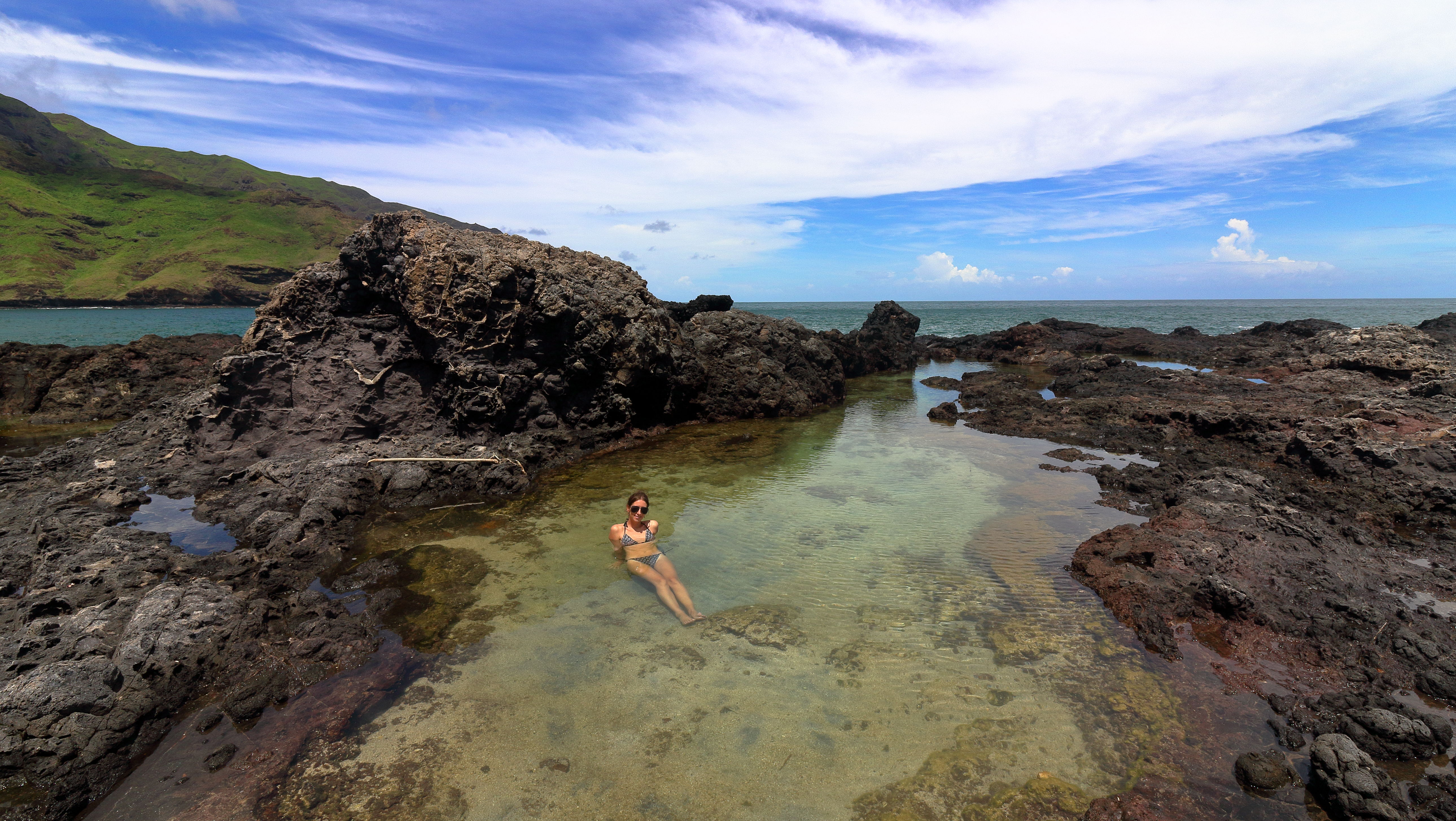
Sarah Frolicking (well, in a very broad sense of the word. I just like saying it. Try it. Out loud. Frolicking. It’s a wonderful word don’t you think? Rolls off the tongue nicely.) 
A beautiful picture of one of the many bird species that are numerous on Ua Huka (don’t ask me which species!) 
Sarah learns how to make some traditional Marquesian cuisine. Here we see Silvain pounding baked breadfruit with a ‘stone penis’ while the family looks on. It’s really very tasty stuff. * Warwick Clay’s ‘South Pacific Anchorages’ is another one that I would recommend, but with caution. They missed out the best and most protected anchorage in the Gambier Islands because in order to get there you have to sail through un-charted waters.
The ‘South Pacific Crossing Guide’ is another one to use with caution, but at least in that book they make it clear that it is not to be used as a comprehensive guide.
‘Charlie’s Charts’ are old but still very valuable.
We have found the collection of google earth imagery and the scanned charts and notations posted via the ‘Soggy Paws’ website to be particularly useful in the Marquisas Islands. I expect they will be even more useful when we venture to the Kingdon of Tonga, Fiji and Vanuatu, which are notoriously poorly-charted. Download them before setting sail into the Pacific!